 '
'
Malheur River Trail
Malheur National Forest
Difficulty: Moderate
Distance: 7.6 miles (one-way)
Elevation Gain: 800 feet
Best Time to Go: May-December
About this Hike
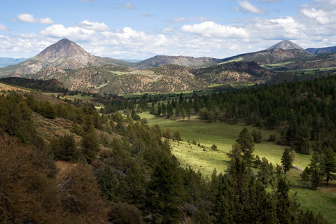
Follow the Malheur River Trail as it traverses along the steep canyon walls before dropping to scenic river banks of the Malheur Wild and Scenic River, lined with old growth pine, larch, and fir trees. Designated as a Wild and Scenic River, this remote trail provides travelers with unrivaled rugged beauty as well as solitude. Stop and fish for red band trout or look for eagles and osprey while negotiating this 7.6 mile trail. Hikers can choose to hike out and back, or leave a car at each end of the trail.
Getting There
1. From John Day, head south on Highway 395 for 9.7 miles until you see a sign pointing left for "USFS Rt. 15; Wickiup CG 8." Turn left at this point for County Road 65, which later becomes Road 15.
2. After 13.6 miles on this road, turn left at a 4-way intersection with a stop sign for Road 16 toward Logan Valley.
3. Continue on this road for 5.3 miles and then turn right on Road 1643 just before reaching Logan Valley.
4. Continue on this gravel road for 9 miles, following signs for "Malheur River."
5. After 9 miles you'll reach a fork - veer left on Road 1651 for 1.3 miles until reaching the parking area.